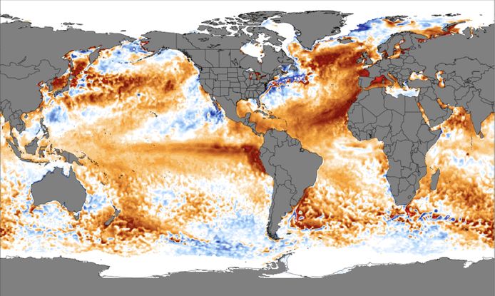
Record high temperatures are measured in the North Atlantic Ocean. Scientists have never seen such high surface temperatures, and they have for three months. The average temperature is currently 22.7°C. This is at least 0.5°C above the previous record of 2010. That is why scientists are very concerned.
The first record was broken this year on March 5th. Then the average temperature in the North Atlantic Ocean rose to 19.9 degrees Celsius. Since then, temperatures have been holding steady at record levels. On June 11, temperatures reached a temporary high of 22.7°C. It is not surprising, therefore, that science has viewed these developments with awe and apprehension.
Read more below the image.
Several factors play a role in why the North Atlantic experiences exceptionally high temperatures. First of all, the so-called trade winds have been weaker than usual since March. These winds blow from east to northeast, which cools the surface waters in the eastern parts of the North Atlantic Ocean. This cools the water. This is happening less now, causing ocean temperatures to rise.
In addition, in 2023 so far, there is a lack of Saharan dust, which generally has a cooling effect on the northern part of the Atlantic Ocean. Large clouds of this dust usually blow over the ocean from the deserts of North Africa, but this year the concentration is markedly low, even at record levels for June. Research has shown that dust causes significant cooling, especially at this time of year.
The global rise is under way
The unusual temperatures in the Atlantic Ocean are part of a pattern of above-average surface temperatures in all oceans worldwide. The Earth’s average surface temperature is currently 20.9°C. This is down from 21.1°C on April 1, but still 0.2°C higher than the previous record from 2022.
Read more below the image.
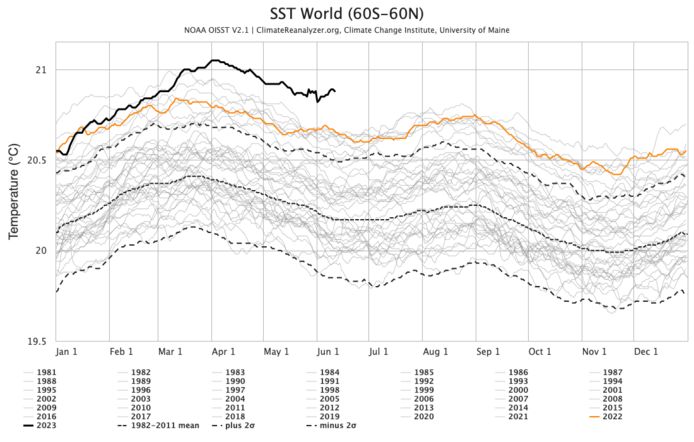
These unprecedented temperatures are the result of a combination of factors related to El Niño and unusually high temperatures in the North Atlantic Ocean. In addition to these factors, climate change contributes to a rise in sea water temperatures in the long term. Also, new shipping regulations have greatly reduced sulfur emissions, reducing the cooling effect of sulfate aerosols.
What are the consequences of this heat wave in our oceans and will it continue?
The level of high temperatures in the North Atlantic Ocean has an important effect on subtropical storms. Warmer oceans provide more energy to tropical systems and can produce stronger storms when other factors allow. For example, previous years with a warm eastern Atlantic (2010, 2017, 2020…) showed very active hurricane seasons. Although that won’t necessarily be the case now thanks to a powerful El Niño. Historically, this weather phenomenon actually reduces the likelihood of severe hurricane seasons in the Atlantic.
This means that there are likely to be fewer tropical storms and weaker systems. Although the Atlantic is experiencing record heat, experts from organizations such as NOAA expect this year to be somewhat average as a result. However, there is more uncertainty in the outlook for this year.
Read more below the image.
Weather models indicate that the atmospheric response to the developing El Niño in the eastern Pacific Ocean is beginning to take shape. This would again give us the usual air pressure distribution and position of the subtropical jet stream. This, in turn, could lead to a decrease in anomalous sea surface temperatures in the North Atlantic. Although it remains to be seen for now. In any case, scientists are watching this closely.
Will the hurricane bear your name this year? What is the difference with tornado? Does it also happen in Europe? 5 questions answered (+)
What about the heat in our country? Weather lady Jill Peters explains
El Niño is officially back, with possible heat records as a result: what kind of weather phenomenon is this? And what can we expect in our country? (+)
Unlimited free access to Showbytes? Which can!
Log in or create an account and never miss a thing from the stars.